Hello and welcome to the details of ‘Very dangerous’ super typhoon nears US Pacific islands and now with the details
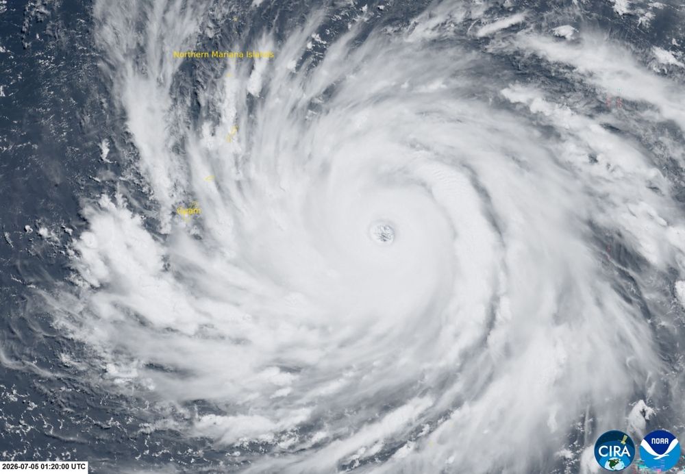
Nevin Al Sukari - Sana'a - This satellite image handout from the Cooperative Institute for Research in the Atmosphere (CIRA) in partnership with the Regional and Mesoscale Meteorology Branch (RAMMB/NOAA) and the Colorado State University (CSU) taken on July 5, 2026 at 01:20 UTC shows the super typhoon Bavi as it develops and nears Guam and the Northern Mariana islands in the western Pacific Ocean. —NOAA handout via AFP pic
NEW YORK, July 5 — People in Guam and the Northern Marianas moved to emergency evacuation centers and made last-minute preparations today, hours before a “super typhoon” was projected to bulldoze through the US Pacific territories.
Super Typhoon Bavi was forecast to roar westwards over the area at around 10am tomorrow (6pm Malaysian time) with winds of 260 kilometres per hour — equivalent to a category 5 hurricane — and gusts of up to 315 kph.
The National Weather Service (NWS) called the typhoon “very dangerous”, warning of “tropical storm force” winds from Sunday afternoon or evening and “catastrophic” damage near the system’s center later.
“Significant flooding from torrential rains, and coastal inundation are expected,” the NWS said, with projected waves of up to 35 feet (10.7 meters) — the height of a 10-storey building — creating “extremely dangerous” conditions at sea.
There were few cars on the roads in Guam on Sunday as heavy rain and strong winds lashed the island.
Pinky Cubacub, 55, said as she boarded up the windows of her eatery that she had lined up early on Saturday to buy $500 worth of plywood at a lumber store.
“I cannot afford to lose so many days. It hurts,” she told AFP. “Because I just started, whatever we’re making right now is just for rent, utilities, and my people, and supplies. I don’t even pay myself yet.”
Call center employee Arabella Paulino, 48, said: “My girls were saying to me it’s scary. But it will be okay.”
“My house is concrete, so the worst that can happen is a window could blow in,” she told AFP.
Japanese tourist Miku Sakurai, 25, was supposed to fly back to Tokyo with her friends on Sunday but their flight was cancelled because of the weather.
“We will stay in the hotel when the storm comes. I am scared,” the office worker told AFP.
Around a dozen surfers, however, were making the most of the windy conditions at one beach in Guam’s Talofofo Bay.
“There’s quite a lot of debris in the water but it’s a lot of fun,” said one of them.
‘Praying’
The Northern Marianas in the western Pacific has a population of around 40,000, and nearby Guam — a separate US territory, although both are part of the Marianas archipelago — about 170,000.
Super Typhoon Sinlaku, which hit the region in mid-April, knocked out power for tens of thousands of inhabitants, uprooted trees, overturned cars and ripped metal roofs off buildings.
In 2023 another massive typhoon, Mawar, the biggest in decades, caused devastation too.
This morning, Bavi was forecast to pass nearest to Rota, a small island roughly halfway between Guam and Saipan, the Northern Marianas’ main island and home to around 1,500 people.
“By working together and taking the necessary precautions, we can help protect our families, neighbors and community. We pray for the safety of our people,” Rota mayor Aubry Hocog said.
Teams from the Federal Emergency Management Agency (FEMA) were on the ground in Guam and its distribution center was stocked with 1.1 million liters of water, 1.2 million meals, 6,700 cots and 90 generators.
The NWS said the “window to evacuate or seek shelter is closing”, and Guam opened five evacuation centers in schools with total capacity of 1,900, primarily for those in vulnerable homes.
Authorities had “learned a lot of lessons that came from Mawar” and were better prepared when Sinlaku hit, said local official Damon Michael Borja, noting areas such as electricity and water supply “and just overall the health and safety of our people.”
From “almost three months to get power and water back on for all the places during Mawar, Sinlaku took almost… three weeks,” Borja told AFP at Guam’s Homeland Security headquarters.
El Nino
The world’s oceans experienced their hottest June on record and could set fresh highs in the months ahead, the European Union’s Copernicus Marine Service said on Wednesday.
Warmer oceans help tropical storms to intensify and add more moisture, which can fall as heavy rain.
The World Meteorological Organization warned on Friday that El Nino, which typically occurs every two to seven years and lasts nine to 12 months, has already begun in the tropical Pacific and is likely to be strong.
The natural climate phenomenon warms surface temperatures in the central and eastern equatorial Pacific Ocean, bringing worldwide changes in winds, pressure and rainfall patterns. — AFP
These were the details of the news ‘Very dangerous’ super typhoon nears US Pacific islands for this day. We hope that we have succeeded by giving you the full details and information. To follow all our news, you can subscribe to the alerts system or to one of our different systems to provide you with all that is new.
It is also worth noting that the original news has been published and is available at Malay Mail and the editorial team at AlKhaleej Today has confirmed it and it has been modified, and it may have been completely transferred or quoted from it and you can read and follow this news from its main source.


