On September 2nd the partnership started PhiSat-1, a satellite that contains a camera with hyperspectral and thermal capabilities as well as the Myriad 2 Vision Processing Unit (VPU) or the “Smart” chip from Intel Movidius. PhiSat-1 and a newer version, PhiSat-2, monitor polar ice, soil moisture, fire activity, ships at sea, plant growth and more. While the first data processing for the first satellite is performed on site, the process is improved in the newer version as the AI system “learns” how to do this. Both versions will also test and improve inter-satellite communication systems.
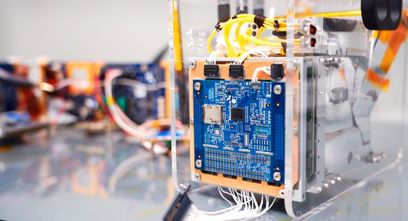
Intel’s Myriad 2 Vision Processing Unit on the PhiSat-1. Photo: Tim Herman / Intel
Jonathan Byrne, head of Intel Movidius technology office and chief drone pilot, told Ctech in an interview what makes this satellite so special.
“The technology used is quite simple,” Byrne explained, adding that it is most commonly used in drones, camera systems, and other devices that require low power consumption. In 2017, the partners began working on the project and turned to Ubotica Tecnologías, a Spanish company that developed the board for space travel. In order to simulate the dangerous radioactive conditions in space, the chip was tested at the CERN Large Hadron Collider, the world’s largest particle reactor in Switzerland, and blasted with high-energy particles that it could withstand. “Because transistors are so small, they are very susceptible to high levels of ionized radiation,” said Bryne.
Chip design for space applications is very limited as it requires high quality, complex hardware and current VPUs in space are 20 years behind technology because they are very expensive and take several years to develop, explained Bryne. “The Myriad 2 is
a commercial off-the-shelf chip. We took a device that was in 99% of the drones and instead of spending all the money on developing the technology, we used and optimized the existing technology, ”he said.
“Our processors use low-power chips to study satellite operations to study future applications for this technology, and we’ve shown that it can work in space,” he said.
The hardware can run on multiple satellite networks. The low-power technology offers further advantages: For example, it does not overheat like most devices in space and is also energy-efficient.
The European Space Agency (ESA) originally developed the LEON4 core processor and made this device available to others. Movidius used this design and then built an improved system.
Bryne added that most satellites are gigantic devices these days but are incapable of generating large amounts of data. Like most smart device manufacturers, developers are trying to miniaturize them while reducing their costs. The AI monitors the images and eliminates the need for human analysis. The PhiSat-1 spectral camera can differentiate between clouds and other data such as unique events on earth such as forest fires and decide which information needs to be sent back to Terra Firma. It uses artificially developed neural networks to process the data and reduces the camera’s bandwidth by 60%, which also makes production cheaper.
Head of Technology Office and Chief Drone Pilot at Intel Movidius Jonathan Byrne. Photo: Intel Movidius
“Our satellite looks at images as they are generated in space and decides whether or not to send them to us,” said Bryne, adding that this could be used to predict various events. The satellite is currently working on the detection of forest fires, low-flying planes and clouds. Other satellite networks can also be updated.
As a rule, such images must first be inspected by people, who then have to make people aware that a fire is breaking out at certain coordinates. However, this satellite will eliminate that need. “It converts raw data into actionable data and can notify people instantly,” said Bryne.
Technicians are currently working on PhiSat-2, which can run AI systems that can be installed on an even faster and easier interface. “Now we’ve got the technology down to the size of a carton of cereal,” said Bryne.
PhiSat-2 is designed to monitor ships at sea that rely on radios to report their position, detect ice and water, or flood plans that are not visible to normal satellite cameras. The hyperspectral camera could be used to detect algal blooms. Scientists can predict whether a field will be in prime condition when it emits infrared light and predict future economic and environmental damage. Hyperspectral data can provide very specific details from far above the earth’s atmosphere and at the same time optimize the quality.
Not only are these satellites working to better improve the Earth’s data, but they also rely on green energy – namely solar panels – to do their job. PhiSat-1 will remain in orbit for a year and a half.
In addition to Ubotica and ESA, Intel Movidius worked with several European groups to complete the project, including the University of Pisa, Cosine and Sinergise.
“The field of remote sensing and earth observation is constantly evolving, and we are seeing a growing number of agencies using optical cameras with spectral analysis to analyze images of locations on earth and monitor algal blooms, ice sheets, fires, crops and more” Said Bryne.
In an effort to develop inexpensive CubeSats or miniaturized satellites, prices will drop to around $ 50,000, and the size of the cameras will also drop. Multiple versions can be sent into space and routinely monitored.
The satellite was produced in Leixlip, Ireland, the only location where Intel produces semiconductors outside of Israel and the US
These were the details of the news The world’s first AI satellite scans the earth for climate anomalies for this day. We hope that we have succeeded by giving you the full details and information. To follow all our news, you can subscribe to the alerts system or to one of our different systems to provide you with all that is new.
It is also worth noting that the original news has been published and is available at de24.news and the editorial team at AlKhaleej Today has confirmed it and it has been modified, and it may have been completely transferred or quoted from it and you can read and follow this news from its main source.