We show you our most important and recent visitors news details Hurricane Otis makes landfall near Acapulco as Category 5 storm in the following article
Hind Al Soulia - Riyadh - ACAPULCO, Mexico — Hurricane Otis made landfall near Acapulco, Mexico, early Wednesday as a Category 5 storm, delivering what forecasters warned could be a “nightmare scenario” for Mexico’s southern coast as it threatens to cause catastrophic damage with destructive winds, heavy rainfall and storm surge.
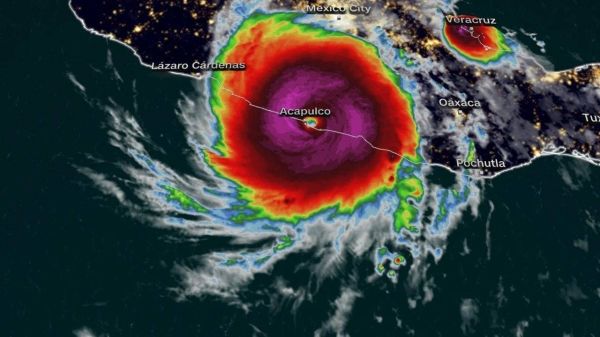
Otis’ center slammed into Mexico’s coast around 12:25 a.m. local time with sustained winds of 165 mph, the National Hurricane Center said.
The storm is expected to rapidly weaken as it presses inland and over southern Mexico’s higher terrain, where it is forecast to dissipate Wednesday night, the hurricane center said.
On Tuesday, Mexican President Andrés Manuel López Obrador implored coastal residents of the state of Guerrero, which includes the beach resort city of Acapulco, to seek shelter and stay away from rivers, streams, and ravines ahead of the storm’s landfall.
A hurricane warning is in effect for coastal Punta Maldonado westward to Zihuatanejo. A hurricane watch and tropical storm warning are also active from Lagunas de Chacahua to Punta Maldonado.
Otis’ primary threats are damaging winds, heavy rainfall and dangerous storm surge as it barrels toward Acapulco, home to roughly 800,000 people.
“This is an extremely serious situation for the Acapulco metropolitan area with the core of the destructive hurricane likely to come near or over that large city early on Wednesday,” the hurricane center said late Tuesday. “There are no hurricanes on record even close to this intensity for this part of Mexico.”
Strong winds of up to 73 mph were expected to reach the Mexico’s Pacific coast Tuesday evening and then spread to other areas throughout Wednesday.
Otis is also forecast to create life-threatening surf and rip current conditions. Hurricane-force winds extend outward up to 30 miles from the center while tropical-storm-force winds extend outward up to 70 miles, the hurricane center explained.
Those winds are forecast to combine with a “potentially catastrophic storm surge” that could cause life-threatening coastal flooding near where it’s forecast to make landfall Wednesday morning.
“Near the coast, the surge will be accompanied by large and destructive waves,” the hurricane center said.
Additionally, between 8 to 16 inches of rain totals are expected through the end of the week, with some areas seeing up to 20 inches of rain. The heavy rainfall could lead to flash and urban flooding as well as mudslides in higher terrain areas, the hurricane center warned.
Otis had been rapidly intensifying throughout Tuesday, gaining 80 mph in a 12-hour period. It became the fastest intensifying hurricane in Eastern Pacific history, according to Phil Klotzbach, a research scientist in the atmospheric science department at Colorado State University.
For context, rapid intensification for hurricanes means the storm’s maximum sustained winds increased by at least 35 mph in 24 hours or less.
If Otis makes landfall as a Category 5 hurricane, it would be the first Category 5 landfall for the East Pacific, according to the NOAA Hurricane Database. The previous strongest landfall was Hurricane Patricia in 2015, which made landfall as a Category 4 Hurricane with winds of 150 mph.
Unlike Otis, which is forecast to make landfall close to a major urban area, Patricia plowed through a sparsely populated and mountainous stretch of the coast, sparing Puerto Vallarta and Manzanillo.
And while Patricia hit the coast as a Category 4 storm, it quickly degenerated and left a narrow path of severe damage it its wake, according to the National Hurricane Center. Two deaths were reported as a direct result of the storm, the center said. — CNN
These were the details of the news Hurricane Otis makes landfall near Acapulco as Category 5 storm for this day. We hope that we have succeeded by giving you the full details and information. To follow all our news, you can subscribe to the alerts system or to one of our different systems to provide you with all that is new.
It is also worth noting that the original news has been published and is available at Saudi Gazette and the editorial team at AlKhaleej Today has confirmed it and it has been modified, and it may have been completely transferred or quoted from it and you can read and follow this news from its main source.
