Now researchers have developed specially adapted drones to collect data from an active volcano in Papua New Guinea (PNG).
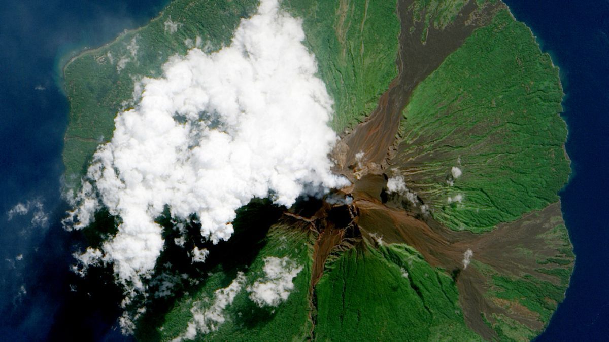
The drones could help local communities monitor nearby volcanoes and predict future eruptions. Your measurements could also tell us more about the most inaccessible, highly active volcanoes on the planet and how volcanoes contribute to the global carbon cycle.The Manam volcano is located on an island only 10 kilometers wide off the northeast coast of PNG. Over 9,000 people live on the island and Manam Motu, as it is known locally, is one of the most active volcanoes in the country. In 2004, a major outbreak from Manam forced the entire island to evacuate to the mainland, devastating crops and people’s homes.
Scientists have a number of different ways to predict when a volcano will explode. You can monitor earthquake activity in the area to spot tremors, which almost always occur before eruptions, and look for bulges in the volcano’s sloping walls when magma builds up underneath.
If the sky allows it, satellites can also quickly record and measure volcanic emissions of gases such as sulfur dioxide (SO2). Changes in these gas emissions can indicate more activity in the volcano below.
“Manam hasn’t been studied in detail, but we were able to see from satellite data that it is causing heavy emissions,” said University College London volcanologist Emma Liu, who led the research team of earth scientists and aerospace engineers.
“We [also] wanted to quantify carbon emissions[s] from this very large carbon dioxide emitter, “added the geochemist Tobias Fischer of the University of New Mexico.
Even though volcanoes emit only a fraction of human carbon emissions, researchers still want to be able to estimate what carbon dioxide (CO2) they are emitting in order to factor this into the remaining carbon budget to limit the effects of climate change.
The international team traveled to PNG and tested two types of long-range drones equipped with gas sensors, cameras and other devices during two field campaigns on Manam Island in October 2018 and May 2019.
The steep slopes of Manam make it incredibly dangerous to even think about collecting gas samples on foot, while the drones could safely fly straight into the billowing springs, helping the research team to more accurately measure its volcanic gas emissions.
The drones flew over 2,000 meters high in Manam’s highly turbulent volcanic plumes and about 6 kilometers from their launch pad, well out of sight of their pilots.
On each flight, the drones took pictures of Manam and its two craters, measured the gas composition directly above the rising springs, and collected four bags of extra gas for quick analysis when the plane touched down.
Aerial images from the drones’ overflights showed that degassing increased in Manam’s southern crater between October 2018 and May 2019. In fact, the volcano erupted soon in June, just a month after the researchers’ second excursion.
Rising volcanic emissions, however, are not the only reliable indicator of whether an eruption is imminent or likely. Therefore, the researchers also examined the ratio between different gases, namely CO2 and SO2, in Manam’s feathers.
This can help detect the rise of hot magma to the surface and the release of carbon-rich emissions that are reported to precede major eruptions.
However, the researchers found that the gas mixture emitted by Manam was largely the same on both excursions.
By integrating their drone measurements into satellite data, the researchers were able to show that Manam is one of the ten strongest degassing volcanoes in the world and emits an estimated 3,700 tons of CO2 and around 5,100 tons of SO2 every day – more than previously assumed.
The team also concluded that most of the carbon emitted by Manam likely came from the Earth’s upper mantle, rather than from sediments from the shallower earth’s crust, which they found by analyzing various carbon isotopes in the gas mixture.
“Our novel approach – that is, ranged combat and high altitude [drone] Operations that enable in-situ measurements – is currently the only possible means of characterizing the gas chemistry of steep, dangerous and highly active volcanoes such as Manam, “concluded the research team in their work.
Future research will require more diligent work from scientists and flight time from drones, as the measurements from this study took only 10 days.
With enough funding to equip and train local scientists, the strategy could be used elsewhere to monitor other dangerously inaccessible volcanoes such as Mayon in the Philippines and Sinabung in Indonesia.
The research was published in Advances in science.
This article was originally published by ScienceAlert. Read the original article Here.
These were the details of the news Drones fly straight into volcanoes for life-saving science for this day. We hope that we have succeeded by giving you the full details and information. To follow all our news, you can subscribe to the alerts system or to one of our different systems to provide you with all that is new.
It is also worth noting that the original news has been published and is available at de24.news and the editorial team at AlKhaleej Today has confirmed it and it has been modified, and it may have been completely transferred or quoted from it and you can read and follow this news from its main source.