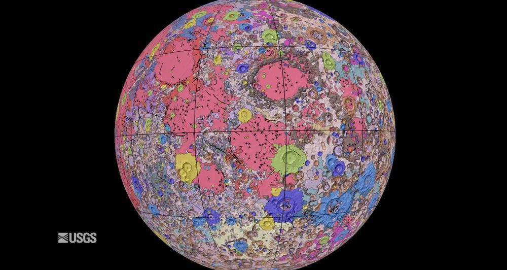
Researchers at the US Geological Survey (USGS), in collaboration with NASA and the Lunar Planetary Institute, have completed one of the most fundamental tools for exploring the moon: the most complete map of the natural earth satellite. After dealing with all available information and more than two decades of work, the Uniform geological map of the moonWith the latest cartography, you can plan missions, choose the best locations for moon landings and settlements, identify future resource occurrences, and have a unique guide to a celestial body that is a natural witness to the origin of the earth. “It’s a unique tool for science,” he warns Jesus Martinez Frías, head of the CSIC’s Meteorites and Planetary Geosciences Research Group and head of the Lanzarote Geosciences Laboratory.
The map shows, at a scale of 1: 5,000,000, the main moon formations, the impact craters caused by the collision of meteorites, and the seas formed by past lava flows.
There are four main types of rock on the moon: gabbroic and alumina-rich basalts from high areas; the KREEP basalts, named after their main components: potassium (K), rare earth elements (rare earth elements, in English) and phosphorus (P); iron and titanium rich basalts; and the so-called moon regolith, which consists of rocks and unconsolidated powders and is particularly rich in ilmenite (rich in oxides in iron and titanium).
Regoliths would enable the creation of protective shields, the construction of roads or the development of plants (Green Moon Project)
This composition is essential for the exploitation of the moon, mainly because of its possible use on the surface of the satellite for the construction of elements that avoid the costly transport of materials from the earth. Martínez Frías is already testing the use of regoliths in Lanzarote to manufacture shields against the radiation of protons from solar emissions and heavy ions from galactic cosmic rays, to build roads or to develop plants (Green Moon Project).
In addition, the map shows the areas of the moon that can be a source of rare earths (15 elements lanthanides from the periodic table, scandium and yttrium), which are considered the gold of the 21st century for making mobile computers, phones, advanced ceramics, Electric cars, microwaves, fiber optics, lighting systems, lasers, rockets or satellites, among other applications. It has become a global problem to find them in the right concentration that will make their extraction profitable.
The map is important in determining and planning the most suitable locations for exploration, moon landings, or settlements
The map is also important in determining and planning the most suitable locations for exploration, lunar landings, or settlement, by pinpointing the geological configuration of the surface. “It is wonderful to see the USGS creating a resource that can help NASA plan future missions,” said current director of geological surveys and former astronaut Jim Reilly at the map presentation.
“The fundamentals of the new map are that they have succeeded in combining all of the existing information by consistently overlaying data layers. If you go to search you will need to bring a geological map. It’s a basic roadmap, ”stresses Martínez Frías.
The researcher highlights that, according to the data of the cartography, the South Pole is the most vulnerable area for future settlements, not only due to the presence of cometary ice, but also due to its mineral composition, which is rich in iron and titanium. and because of the luminosity.
To obtain oxygen, igneous materials (such as ilmenite, anorthite and olivine) can also be used, which contain between 40% and 50% of this element in the form of oxides.
Getting used to, taking advantage of and using the moon as an intermediate base for other space explorations are the main goals this map will enable in the near future. Without forgetting the opportunity to observe on the satellite how the earth was originally.
For drafting the Uniform geological map of the moon The six regional maps created during the missions were used ApolloIn addition to the updated information provided by recent observations of the moon, such as those gathered by SELENE (the JAXA rover, the Japan Aerospace Exploration Agency) or the NASA orbiter laser altimeter.
The unification of the original and most recent data was accompanied by the work of USGS researchers to determine the stratigraphy (rock layers) of the moon and the resolution of inconsistencies found in typologies, ages and descriptions. “This map is the culmination of a decade-long project and provides vital information for new scientific studies that combine site-specific explorations with the rest of the surface,” explains Corey Fortezzo, geologist and lead author at USGS.
You can follow MATTER im Facebook, Twitter, Instagram or subscribe to our here Newsletter
These were the details of the news The most detailed map for exploring the Moon – Pledge Times for this day. We hope that we have succeeded by giving you the full details and information. To follow all our news, you can subscribe to the alerts system or to one of our different systems to provide you with all that is new.
It is also worth noting that the original news has been published and is available at de24.news and the editorial team at AlKhaleej Today has confirmed it and it has been modified, and it may have been completely transferred or quoted from it and you can read and follow this news from its main source.
